2025-2026 Winter Outlook
November 2025, – Forecasters at NOAA’s Climate Prediction Center released the 2025-26 U.S. Winter Outlook for December 2025 through February 2026.
“A slowly-developing La Nina is favored to influence conditions for the upcoming winter across most of the country, according to NOAA’s U.S. Winter Outlook released today by the Climate Prediction Center — a division of NOAA’s National Weather Service. This outlook is for December 2025 through February 2026 and contains information on likely conditions throughout the country for temperature, precipitation and drought.
La Niña conditions continue with sea surface temperatures (SSTs) below average across the central and eastern equatorial Pacific Ocean. La Niña is slightly favored to persist through December-January-February but is likely to remain weak. A transition to ENSO-neutral conditions is expected by early spring 2026.
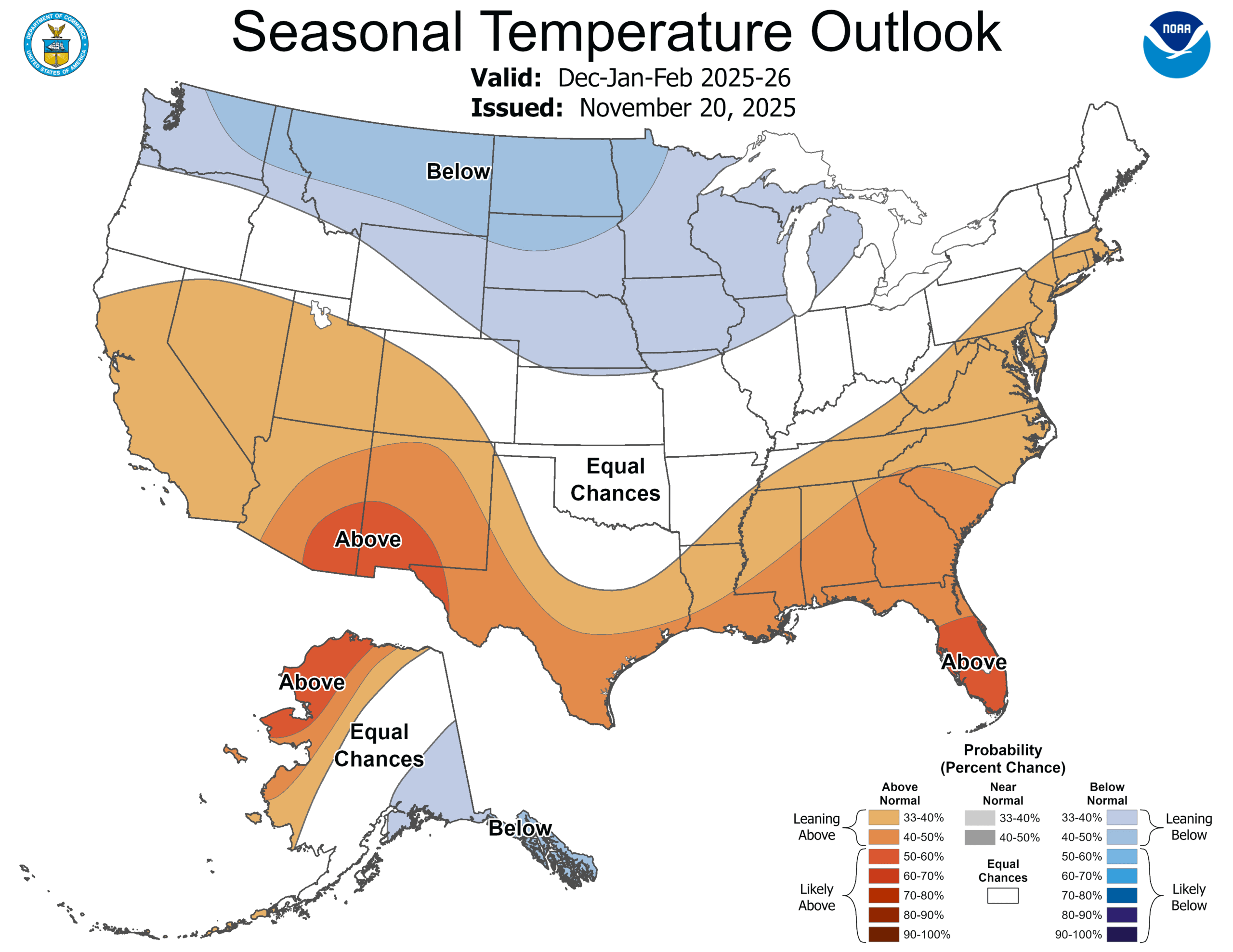
The December-January-February (DJF) 2025-26 Temperature Outlook favors above-normal temperatures across much of the East Coast, Southeast, Gulf Coast, Texas, the Southwest, and California. The DJF Temperature Outlook leans towards below-normal temperatures from the Central Great Lakes, Upper Mississippi Valley, and Northern to Central Great Plains west to parts of the Pacific Northwest. An increased chance of below (above)-normal temperatures is forecast for southeastern (northwestern) Alaska.
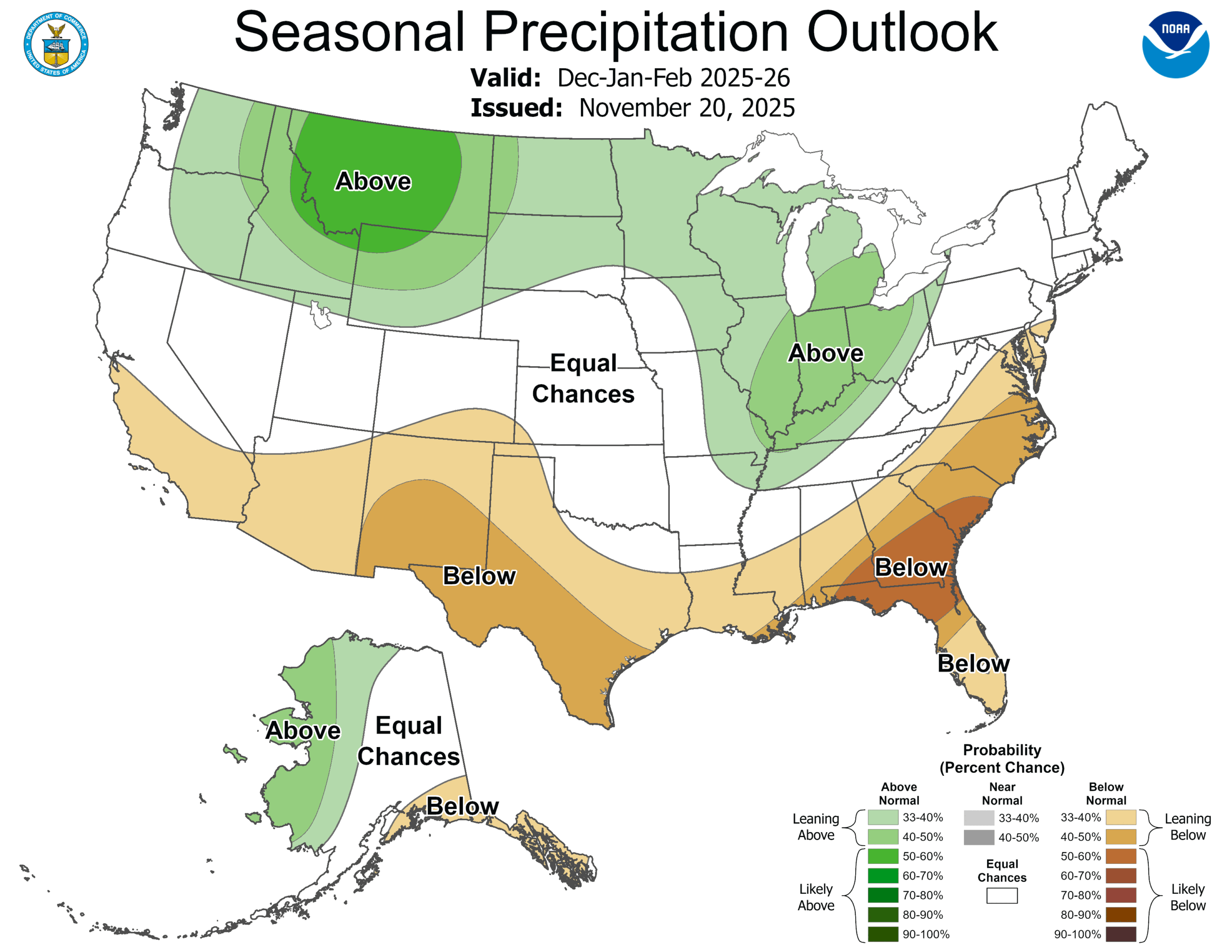
The DJF Precipitation Outlook depicts elevated below-normal precipitation probabilities for portions of the Mid-Atlantic, Southeast, Gulf Coast, Texas,
the Southwest, and California. Above-normal precipitation is favored from the Upper Mississippi Valley and Great Lakes south to the Ohio Valley along with the Northern Great Plains, Northern Rockies, and parts of the Pacific Northwest. An increased chance of below (above)-normal precipitation is
forecast for southeastern (northwestern) Alaska. ”
The 2025-26 U.S. Winter Outlook (December through February):
Precipitation
- Wetter-than-average conditions are favored from the Upper Mississippi Valley and Great Lakes south to the Ohio Valley along with the Northern Great Plains, Northern Rockies, parts of the Pacific Northwest, and northwestern Alaska.
-
The greatest likelihood for drier-than-average conditions are favored for portions of the Mid-Atlantic, Southeast, Gulf Coast, Texas, the Southwest, California, and southeast Alaska.
- Elsewhere, there are equal chances of below-average, near-average or above-average seasonal total precipitation.
The CPC winter forecasts below show the most likely outcome where there is greater confidence, but this is not the only possible outcome. Equal chance display areas where confidence is low, so there is an equal chance of it being among the wettest third, near-normal, or among the driest third.
Temperature
- Warmer-than-average temperatures across much of the East Coast, Southeast, Gulf Coast, Texas, the Southwest, California, and northwestern Alaska.
-
Below-average temperatures from the Central Great Lakes west to parts of the Pacific Northwest, and southeastern Alaska.
- The remaining areas have equal chances of below-, near-, or above-average seasonal mean temperatures.
The CPC winter forecasts below show the most likely outcome where there is greater confidence, but this is not the only possible outcome. Equal chance display areas where confidence is low, so there is an equal chance of it being among the warmest third, near-normal, or among the coldest third.
NOAA’s seasonal outlooks provide the likelihood that temperatures and total precipitation amounts will be above-, near- or below-average, and how drought conditions are anticipated to change in the months ahead. The outlook does not project seasonal snowfall accumulations as snow forecasts are generally not predictable more than a week in advance.
NOAA’s Climate Prediction Center updates the three-month outlook monthly.
- Over the past year, NOAA implemented several upgrades and improvements to its forecasting tools. In late 2023, the experimental Probabilistic Winter Storm Severity Index (WSSI-P) became operational. The product enhances communication with external partners, media and the public by visually representing the likelihood of potential societal impacts due to expected winter hazards over a 7-day period. This is complemented by an existing operational version of the Winter Storm Severity Index (WSSI), which is based on the official National Weather Service forecast of the most likely conditions over the next 3 days.
- NOAA is simplifying its suite of cold weather products to improve messaging of these hazards and provide better decision support services. As of October 2024, the Wind Chill Watch, Warning, and Advisory products were consolidated into the Extreme Cold Watch and Warning and Cold Weather Advisory products, respectively. The Hard Freeze Watch and Warning products were consolidated into the existing Freeze Watch and Warning products, respectively. More information can be found within this hazard simplification project webstory.
- NOAA will make the Experimental Probabilistic Precipitation Portal publicly available beginning in early November. This webpage will enable users to view the Low-End, Expected and High-End amounts of snow and rain, as well as probabilities of exceeding threshold amounts of precipitation. Data will be available through an interactive map, tables and graphics to assist local partners, including emergency management, with decision support.