Sorry, no posts matched your criteria.
Upcoming Events
Jun9Tue20267:30 AM 2026 Yard Waste Collection (North)2026 Yard Waste Collection (North)Jun 9 @ 7:30 AM – 12:00 PM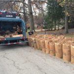 Beginning April 7, 2026, we will resume our yard waste program by picking up the paper lawn and leaf bags. This service will continue through Thanksgiving week, November 24, 2026. Late March, we will deliver[...]Jun15Mon20267:30 AM 2026 Yard Waste Collection (South)2026 Yard Waste Collection (South)Jun 15 @ 7:30 AM – 11:00 AMBeginning April 6, 2026, we will resume our yard waste program by picking up the paper lawn and leaf bags. This service will continue through Thanksgiving week, November 23, 2026. Late March, we will deliver[...]Jun16Tue20267:30 AM 2026 Yard Waste Collection (North)2026 Yard Waste Collection (North)Jun 16 @ 7:30 AM – 12:00 PMBeginning April 7, 2026, we will resume our yard waste program by picking up the paper lawn and leaf bags. This service will continue through Thanksgiving week, November 24, 2026. Late March, we will deliver[...]Jun22Mon20267:30 AM 2026 Yard Waste Collection (South)2026 Yard Waste Collection (South)Jun 22 @ 7:30 AM – 11:00 AMBeginning April 6, 2026, we will resume our yard waste program by picking up the paper lawn and leaf bags. This service will continue through Thanksgiving week, November 23, 2026. Late March, we will deliver[...]7:00 PM Township Board Meeting – JUN @ Palatine Township Town HallTownship Board Meeting – JUN @ Palatine Township Town HallJun 22 @ 7:00 PM – 8:00 PM
 Discussion of agenda items found at https://palatinetownship-il.gov/documents/Jun23Tue20267:30 AM 2026 Yard Waste Collection (North)2026 Yard Waste Collection (North)Jun 23 @ 7:30 AM – 12:00 PMBeginning April 7, 2026, we will resume our yard waste program by picking up the paper lawn and leaf bags. This service will continue through Thanksgiving week, November 24, 2026. Late March, we will deliver[...]Jun29Mon20267:30 AM 2026 Yard Waste Collection (South)2026 Yard Waste Collection (South)Jun 29 @ 7:30 AM – 11:00 AMBeginning April 6, 2026, we will resume our yard waste program by picking up the paper lawn and leaf bags. This service will continue through Thanksgiving week, November 23, 2026. Late March, we will deliver[...]Jun30Tue20267:30 AM 2026 Yard Waste Collection (North)2026 Yard Waste Collection (North)Jun 30 @ 7:30 AM – 12:00 PMBeginning April 7, 2026, we will resume our yard waste program by picking up the paper lawn and leaf bags. This service will continue through Thanksgiving week, November 24, 2026. Late March, we will deliver[...]